Lake Tahoe
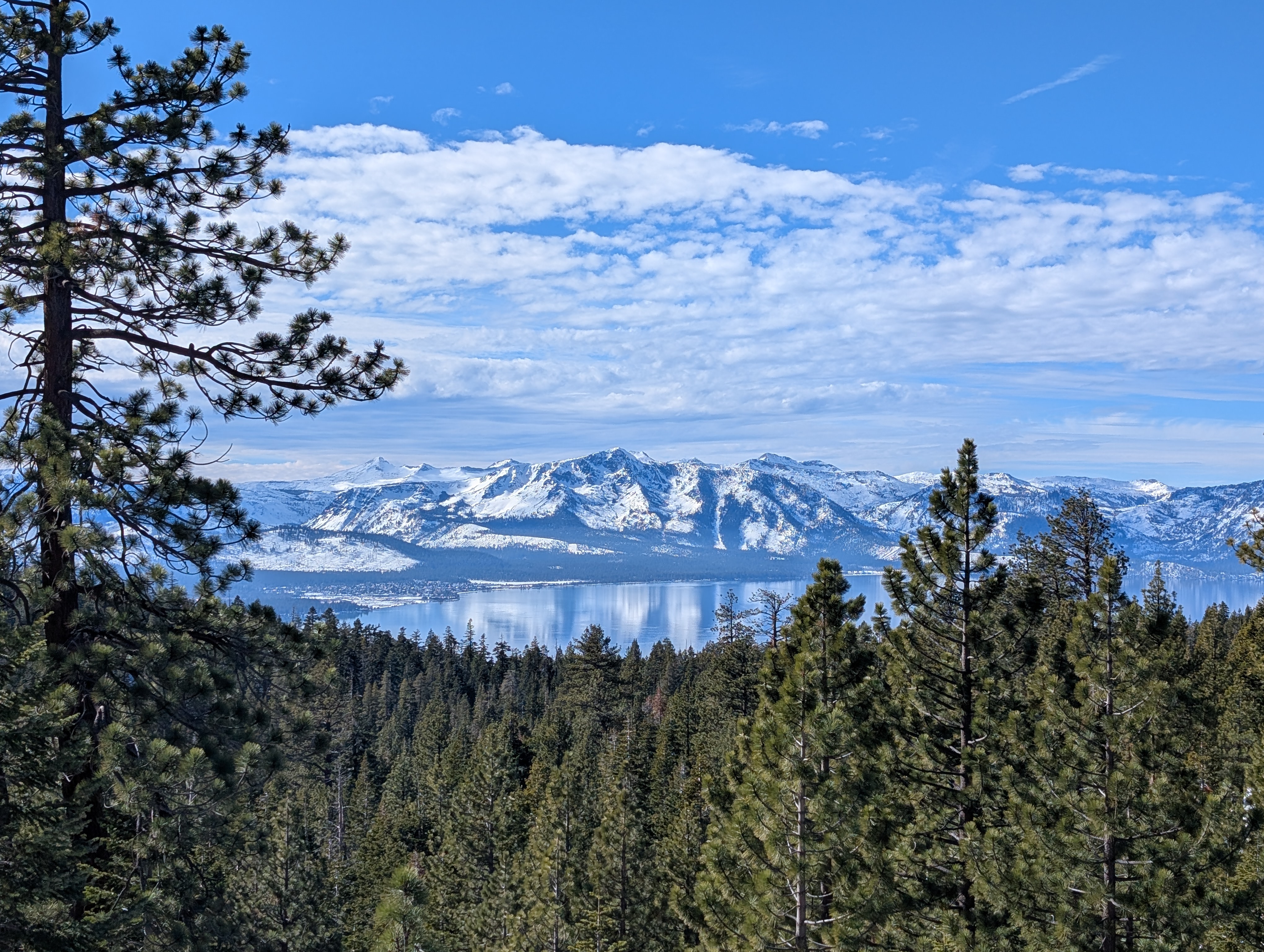
Tahoe, from Washo dáʔaw, simply means lake, and cobalt-blue Lake Tahoe truly is the lake. The largest alpine lake in North America, it attracts visitors from around the world every season of the year for its skiing, hiking, and water sports in a dramatic mountain setting.
The following transportation information is a summary. More comprehensive information on mountain bike, ski, and resort shuttle services around the Tahoe area can be found on Keep Tahoe Blue’s website (which has a particularly detailed section on winter transportation) and on the excellent Linking Tahoe website, run by the Tahoe Regional Planning Association.
- Understanding the Tahoe region
- Getting to the lake
- Getting around the region
- Where to go at Tahoe
- Transit-accessible trailheads
Understanding the Tahoe region
There are two main routes into the Tahoe area: from the north, I-80 and Amtrak run from Sacramento (or Reno) through Donner Pass and the city of Truckee; from the south, US-50 runs from Sacramento through Echo Pass to South Lake Tahoe.
Truckee is located a 12-15mi drive from the lake itself on Hwy 89 (to Tahoe City) or Hwy 267 (to Kings Beach). Each of these roads sees hourly service on TART, the transit agency for the northern half of the lake. Tahoe City and Kings Beach, along with Incline Village, are the main towns in the north, but contiguous vacation developments span much of the western and northern shores.
South Lake Tahoe is sited directly on the lake, and along with Stateline and Kingsbury forms a largely contiguous sprawling town at the heart of the southern shore. South Lake is a major ski center, and as such has a modern faux urbanist center at Heavenly Village, but it is not a particularly walkable town.
Tahoe City to South Lake Tahoe is 30 miles on what is in parts a winding mountain highway. There is minimal transit between the two shorelines; in the summer, the Emerald Bay State Park shuttle service can be used to get down the western shoreline, while in the winter, the only possible option requires going to Reno.
As such, it’s important to decide early on in planning any Tahoe trip what activities to do, and where to do them.
Getting to the lake
North Lake
Capitol Corridor: two daily thruway buses connect to/from Bay Area to Truckee (and Reno). The buses are timed to meet specific trains, and tickets are sold through Amtrak. Check timetables early in the planning process; one of the two daily buses arrives in Truckee after the last Tahoe-bound bus has already departed.
Fare: $27 from Sacramento to Truckee for one adult / $50 from Emeryville, with a 50% companion fare discount for up to 5 others.
California Zephyr: a once-daily long-distance Amtrak train runs from the San Francisco area through Truckee. Eastbound, the train is fairly reliable, but westbound trains originate in Chicago and are notorious for racking up delays over the course of the long journey.
Fare: $50+ from Emeryville to Truckee for one adult, with fares going up in price as seats on the train are sold.
Greyhound: a once-daily bus runs from San Francisco through Truckee, departing early in the morning (at time of writing, 6:30am) and arriving in Truckee in the early afternoon (12:15pm).
Fare: $30+ from San Francisco for one adult, with fares going up as seats on the bus are sold.
North Lake Tahoe Express: shuttles are available from the Reno Tahoe International Airport to destinations around the Truckee and North Lake area, with service 2-5 times a day depending on the route.
Fare: $99 for one adult, with fares as low as $55 per passenger for a group of 5.
Bottom line: from the Bay Area, your best bet is to catch the ~8:00am Capitol Corridor train to the 10:45am thruway bus to Truckee arrving at 1:15pm. Connect to TART for the final leg to the lake.
South Lake
Sacramento/South Lake Tahoe connecting bus: El Dorado Transit runs a once-daily thruway bus that connecting to the Capitol Corridor, with tickets booked through Amtrak.
Fare: $34 from Sacramento to South Lake Tahoe for one adult / $66 from Emeryville, with a 50% companion fare discount for up to 5 others.
South Tahoe Airporter: shuttles runs several times a day from the Reno Tahoe International Airport to Stateline, NV (directly adjacent to South Lake Tahoe, CA).
Fare: $33.25 for one adult, at the time of writing.
Bottom line: from the Bay Area, your best bet is to catch the direct morning Greyhound bus, or the ~8:00am Capitol Corridor train to the 10:45am thruway bus to South Lake Tahoe arrving at 1:15pm. From elsewhere, fly to Reno and catch the Airporter to Stateline.
Getting around the region
In general, the Tahoe Basin has very expansive, free microtransit offerings. Microtransit is on-demand shared rides, like hailing an Uber or Lyft but potentially sharing the ride for part of the trip. For getting around the developed areas of North Lake and South Lake, it offers a compelling door-to-door (or door-to-trailhead) offer. If you normally only use fixed-route transit services, consider trying microtransit.
North Lake and Truckee’s transit service is operated by TART. TART is fare-free for both fixed-route services along the highways, and for TART Connect microtransit. In the Olympic Valley and Alpine Meadows area, Mountaineer Transit offers a free microtransit service as well.
South Lake transit is operated by TTD Transit for fixed-route service and Lake Link for microtransit. Both services are fare-free.
The seasonal, summer-only Emerald Bay Shuttle connects to both TART (at Sugar Pine Campground) and TTD (at the “Y” Transit Center).
Where to go at Tahoe
There is no bad trail in the Tahoe area. The following is a selection of the most popular spots in the Tahoe area that are accessible by transit:
Emerald Bay State Park
On every list of Tahoe sights, Emerald Bay State Park tops the list. The park, home to “Scandanavian” mansion Vikingsholm and the blue-green waters of titular Emerald Bay, is one of the most photographed places in the world, according to California State Parks.
Situated on the most rugged section of Tahoe shoreline, Emerald Bay and adjacent D.L. Bliss State Park offer hike opportunities from a short-and-sweet 2-mile walk down the hill to Vikingsholm to a 7+-mile hike along the shore to and past Emerald Point or Eagle Point.
A seasonal (summer-only) shuttle operates from Sugar Pine Point Campground (connecting to TART ML) seven days a week, and from from the South Lake “Y” Transit Center (connecting to TTD 50 and 55, as well as intercity buses to/from Sacramento) Fridays through Sundays.
Official state park page »
Emerald Bay shuttle information »
Tahoe Rim Trail
The Rim Trail forms a complete loop around Lake Tahoe. Whether you want to thru-hike the full 165-mile trail, or just do day hikes along segments of the trail, there are several ways to access it by transit. The following is a selection of the most convenient ways:
- Tahoe City: access directly from the Tahoe City Transit Center
- Brockway, from Tahoe Vista: access via informal trail running between Regency Way and Hwy 267 (1.9mi, 760ft)
- Brockway, from Carnelian Bay: access via Carnelian Bay Ave (2.2mi, 950ft)
- Incline Village west: access via Barbara St (3.5mi, 2400ft - informal trail)
- Incline Village east: access via Tunnel Creek Road (3.4mi, 1600ft)
- Kingsbury: access via Daggett Pass (1mi, 100ft)
- Stateline: access via Van Sickle Bi-State Park (3.2mi, 1300ft)
- Tahoma: access via Sugar Pine State Park (6.5mi, 1000ft - General Creek Trail or Rubicon Trail)
Sand Harbor
Granite-studded sandy beaches and turquoise waters at Sand Harbor attract a massive number of visitors each year for swimming, paddling, hiking, or simple sightseeing.
As one of the busiest places in the Tahoe Basin, a seasonal East Shore Express bus route runs from Incline Village to the park from June to September. Alternatively, the park is a 3-mile walk along the Tahoe East Shore Trail (a paved bicycle path).
Official state park page »
TTD 28 East Shore Express information »
Olympic Valley
The Olympic Valley, host of the 1960 Winter Olympic Games, is somewhat removed from Lake Tahoe but offers classic Sierra hiking. Several popular hikes leave directly from the developed heart of the valley, with Thunder Mountain Trail running through the main ski area, Shirley Canyon Trail running through the next valley over and around the back to Shirley Lake, and Granite Chief Trail running steeply up to meet the Pacific Crest Trail just before the summit of Granite Chief itself.
Heavenly Gondola
Heavenly Mountain Resort is a classic Tahoe ski resort, but its gondola runs year-round. In the summer, instead of taking skiiers up to the slopes, it offers sightseers an easy way up to high elevations – and the views that come with that – without the hike.
The gondola, located at the Heavenly Village in South Lake Tahoe a short walk from Stateline Transit Center, has a base altitude of 6,630ft and a top station elevation at 9,136ft. Activities and a further ride on the Tamarack Express chair lift to hiking trails and viewpoints await at the top. Unfortunately for budget-conscious visitors, summer season lift access is free for Heavenly ski pass holders, but costs upwards of $100 per adult without.
Heavenly Gondola information »
Transit-accessible trailheads
This map shows transit-accessible trailheads across the Tahoe basin, including seasonal-only services.
Use two fingers to pan and scroll the map.
Hold ctrl and scroll to zoom.