Point Reyes National Seashore: Alamere Falls
- Marin Transit 68
- Stop: Bear Valley Visitor Center
- Travel time: 65min
This is only one of many possible hikes from the Bear Valley Visitor Center. Check out the National Parks website for other options in the park »
Point Reyes National Seashore is the Bay Area’s other world-famous National Park unit. Tucked away in the far western reaches of Marin County, it’s still tantalizingly close to the major urban cores in San Francisco and Oakland and is a common destination for both vacationers and for local visitors. While the Golden Gate National Recreation Area can feel downright urban at times, Point Reyes feels a world away: its forests are home to the rare bishop pine and to some of the more southerly populations of Douglas-fir, Oregon’s state tree. Unlike most of the Bay Area’s open spaces, Point Reyes is largely not grazed by cattle; instead, the landscape is more carefully managed for native plants and grazers.
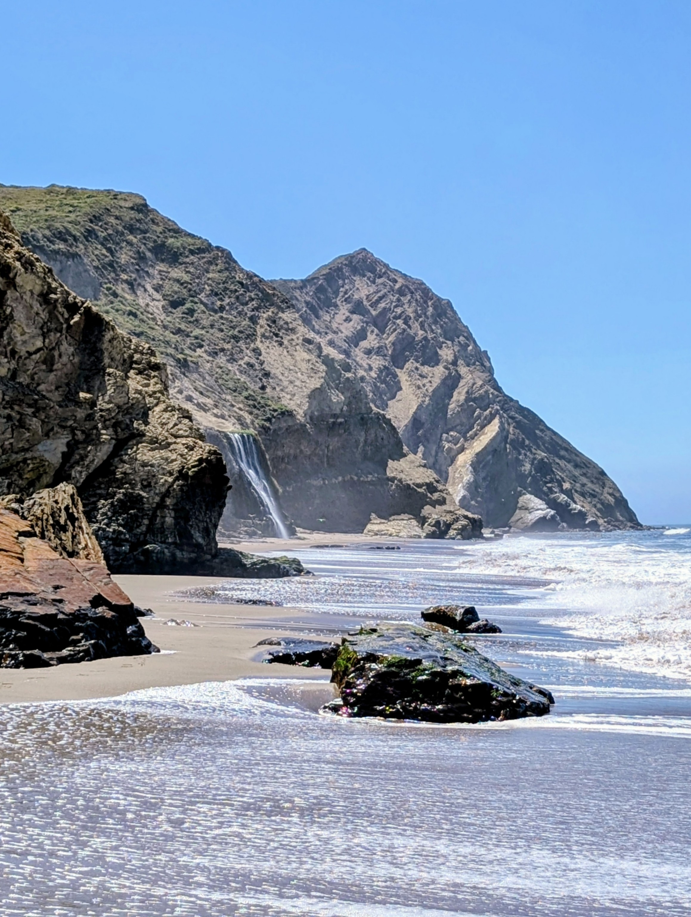
Most tourists like the sound of that, but the biggest attraction is Alamere Falls: one of only two coastal waterfalls in California, seeing its waters reach the beach are the reward for one of the region’s most strenuous popular hikes. Most hikers approach from the south on the Palomarin Trail, with many cutting from the top of the falls down an informal steep, loose route to the beach. The National Park Service strongly advises against the route, warning of unstable soils and rocks, poison oak, and frequent injuries.
This route, from the Bear Valley Visitor Center, follows one of the staff-recommended routes. This is the main visitor center for the park, and staff are on hand to answer questions about wildlife, trails, and potential tide issues. Stop by the Visitor Center to check the tide information on the board inside.
From the visitor center, the trail runs gently up a valley following a creek. Keep an eye out for horses and bicyclists, as the first part of this hike is on multi-use trails. It crosses over at the Divide Meadow, named after the boundary between creeks flowing into Tomales Bay and creeks flowing directly into the Pacific Ocean. The stark difference in land management is clear at this meadow, with tall grasses and shrubs left to grow without grazing.
The trail then begins to descend down Coast Creek toward the ocean. Don’t miss the turnoff for Glen Trail, where you move away from the brightly lit leafy trees of the valley and up to a Douglas-fir covered hill. In parts, the forest seems to surround you; in others, views open up across the forested valley to the forested ridge beyond.
Eventually, the steep hike down to Wildcat Campground begins. As the forest gives way to coastal grasses, the view opens up for the first sight of the ocean stretching out to the horizon from far above.
Facilities are available at the campground near the ocean if needed. Otherwise, follow the trail down until it disappears into the sandy beach, and begin walking south along the beach. At moderate to high tides, the path to Alamere Falls will be blocked. Pay attention to the current and maximum tide and the timing of the tides; the cliffs get steeper and the beach narrower as you head toward the falls.
Alamere Falls itself is a set of waterfalls down a 40-foot-tall cliff. At higher tides, the water falls dramatically directly into the ocean; seeing this is not possible from this route. Instead, see – and hear – the waterfall crash onto the sand mere feet from the ocean.
On the way back, follow the trail up from the Wildcat Campground, but take a left onto the Coast Trail instead, a trail with dramatic parting views of the Wildcat area and surrounding coastal bluffs. Follow it back into the forest, eventually meeting up with the Glen Trail and retracing the route back to the visitor center.
If the next bus to arrive is an Inverness-bound bus, consider catching it up into Point Reyes Station to relax and wait at a cafe, boutique, or grocery store for the return trip.